COSC-574: Automated Reasoning
Project 3
Fall 2017
Due: R 12/7 @ 11:59 P.M.
10 points
For this project, we're going to France. Formidable!
Using Java, implement
- uniform-cost search as the method ucs,
- greedy best-first search as the method gbfs, and
- A* as the method astar.
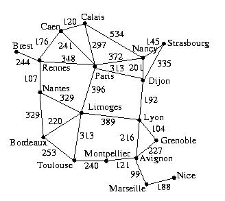
Encode the following weighted graph:

Use the following latitudes and longitudes for the cities to
write a function that returns the estimated distance between two
cities.
Paris, 48:51:00N 2:20:00E
Caen, 49:15:00N 0:20:00W
Calais, 50:57:36N 1:57:00E
Dijon, 47:21:00N 5:02:00E
Lyon, 45:44:00N 4:52:00E
Grenoble, 45:21:36N 5:19:12E
Avignon, 43:50:00N 4:45:00E
Marseille, 43:18:00N 5:25:00E
Nice, 43:42:00N 7:21:00E
Montpellier, 43:38:00N 3:53:00E
Toulouse, 43:37:00N 1:27:00E
Bordeaux, 44:50:00N 0:37:00W
Limoges, 45:30:00N 1:10:00E
Rennes, 48:07:00N 1:02:00W
Brest, 48:24:00N 4:30:00W
Strasbourg, 48:32:24N 7:37:34E
Nancy, 48:50:00N 6:10:00E
Nantes, 47:15:00N 1:30:00W
The file graph.txt should help you save
a few keystrokes, especially if you know how to program.
There is also a copy of this file on cs-class, which you can copy by
executing
cs-class% cp ~maloofm/cosc574/graph.txt ./
In addition to computing a solution and its cost for the initial
and goal cities, each search method should also compute:
- the number of nodes explored, entered, or visited
- the number of nodes expanded (i.e., the total number of successors)
- the number of nodes maintained (i.e., stored in the frontier)
Main.main should use each of the three search methods to
find a path between the following initial and goal cities:
| Run | Initial State | Goal State
|
| 1 | Brest | Marseille
|
| 2 | Montpellier | Calais
|
| 3 | Strasbourg | Bordeaux
|
| 4 | Paris | Grenoble
|
| 5 | Grenoble | Paris
|
| 6 | Brest | Grenoble
|
| 7 | Grenoble | Brest
|
Main.main should print the solution, the path cost of the
solution, and the counts.
For each search method over the seven city pairs, compute the
following:
- the average number of nodes explored or entered
- the average number of nodes expanded (i.e., the total number of successors)
- the average number of nodes maintained (i.e., stored in the frontier)
- the average number of times it found the optimal solution
Place these averages in a file named README.
Write a paragraph that compares and contrasts the search algorithms
in terms of these statistics. What differences or similarities do
you see between the informed search algorithm and the optimal search
algorithms?
What differences or similarities do you see between the two optimal
search algorithms.
Include this file with your submission.
Instructions for Electronic Submission
In a file named HONOR, provide the following information:
Name
NetID

In accordance with the class policies and Georgetown's Honor Code,
I certify that, with the exceptions of the course materials and those
items noted below, I have neither given nor received any assistance
on this project.
When you are ready to submit your project, create the zip file
for uploading by typing:
$ zip submit.zip Main.java (other java files) README HONOR
Upload submit.zip to
Autolab.
You can submit your assignment p3 five times.
The autograder will simply call Main.main.
Plan B
If Autolab is down, upload your zip file to Canvas.
Copyright © 2019 Mark Maloof. All Rights Reserved.
This material may not be published, broadcast, rewritten,
or redistributed.
