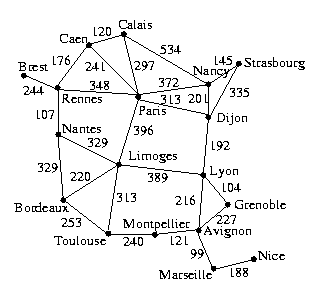
Use the following latitudes and longitudes for the cities to write a function that returns the estimated distance between two cities.
Paris, 48:51:00N 2:20:00E
Caen, 49:15:00N 0:20:00W
Calais, 50:57:36N 1:57:00E
Dijon, 47:21:00N 5:02:00E
Lyon, 45:44:00N 4:52:00E
Grenoble, 45:21:36N 5:19:12E
Avignon, 43:50:00N 4:45:00E
Marseille, 43:18:00N 5:25:00E
Nice, 43:42:00N 7:21:00E
Montpellier, 43:38:00N 3:53:00E
Toulouse, 43:37:00N 1:27:00E
Bordeaux, 44:50:00N 0:37:00W
Limoges, 45:30:00N 1:10:00E
Rennes, 48:07:00N 1:02:00W
Brest, 48:24:00N 4:30:00W
Strasbourg, 48:32:24N 7:37:34E
Nancy, 48:50:00N 6:10:00E
Nantes, 47:15:00N 1:30:00W
The file graph.txt should help you save a few keystrokes, especially if you know perl. There is also a copy of this file on seva, which you can copy by executing
seva% cp ~maloofm/cosc387/graph.txt ./
- best-first search and
- A*.
Each function should return the path and its cost.
| Run | Initial State | Goal State |
|---|---|---|
| 1 | Brest | Marseille |
| 2 | Montpellier | Calais |
| 3 | Strasbourg | Bordeaux |
| 4 | Paris | Grenoble |
| 5 | Grenoble | Paris |
| 6 | Brest | Grenoble |
| 7 | Grenoble | Brest |
- what was the average number of nodes entered (i.e., visited)?
- what was the average number of nodes expanded?
- what was the average number of nodes maintained (i.e., stored)?
- how often did it find the optimum?
Place these results a README file or in comments at the top of your source file.